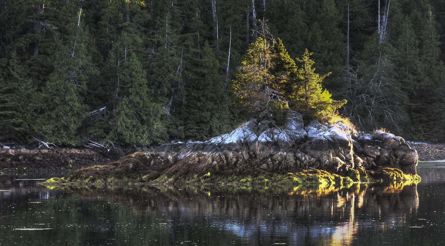
Scow Bay, Lay Day

Today we had set aside to explore this area. The clouds had departed in the darkness of morning but by sunrise they were back, although at around 1000 feet, so no fog.

We took our time getting moving and I made pancakes and bacon for a late breakfast. Around 11:30 we launched the dinghy. Our first stop was at the sailboat that came in last night. Diva was out of Whidbey Island and manned by Jeff and Marin. They said they had a rough ride yesterday around Cape Cook as the Southeasterlies came up causing confused and rough seas. They were about to raise their anchor and continue south to get water and fuel.

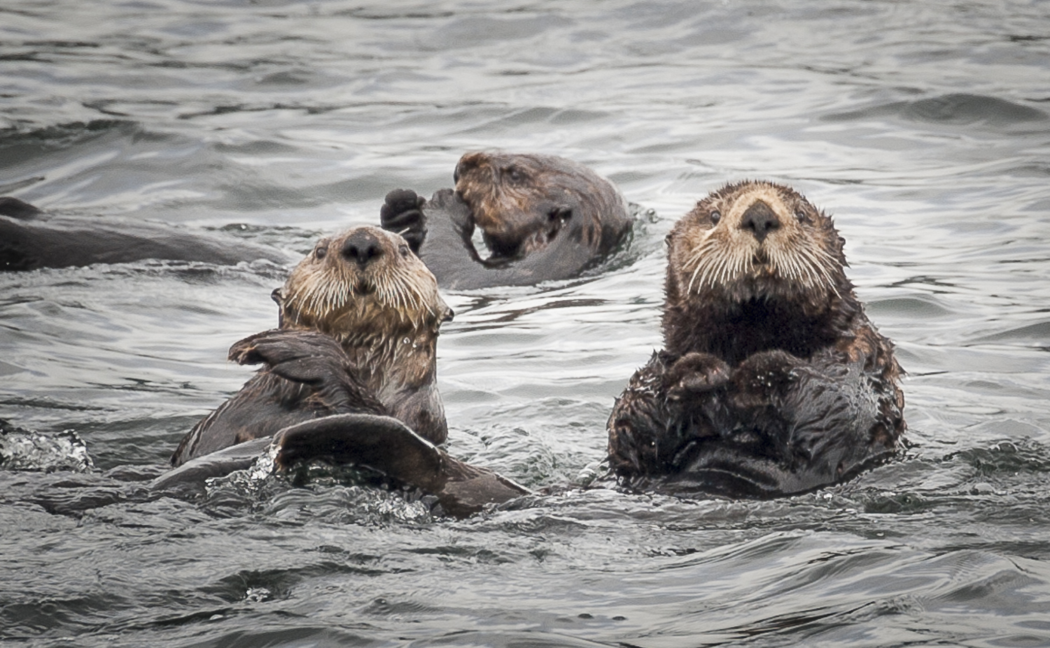
We pointed the dinghy toward the inner basin at the head of the bay. It was drying earlier, but with high tide approaching and the water plus 7 to 9 feet, we managed to go all the way to the end and circumnavigate both the small and large island. The path around the large island shows only green on our charts, but we saw no lower than three feet. It was a good exploration…and we enjoyed the company of a few otters.

As we exited the back cove, Karen spotted the sea otter she had been playing hide and seek with since yesterday, fondly called “The Log” as he would just zone out and drift around the anchorage. We approached very slowly in the dinghy and he seemed content to just watch us. A few feet at a time we moved closer, watching his body language to make certain we did not scare him.

What a ham! 

What a ham! 

He was very gracious and allowed us to approach as close as 10 feet. He never deviated from his grooming chores. After about 10 minutes, lots of pictures, and a video, we motored on our way, the otter never moving from his spot or stopping his grooming. That was a very special otter, he must have sensed we meant him no harm and only wanted a close encounter.

West Nook and South Nook, also off Gay Passage, were the next two destinations for our explorations. These anchorages held little appeal because they seemed very open and the shore lines were littered with driftwood. With Scow Bay just around the corner, I would always anchor here.

About 15 minutes after had settled back aboard we saw lightning and heard thunder. In the nine years we have been cruising the Pacific Northwest, this was a first. It produced some rain and then was gone as quickly has it had come.

My plan for the afternoon was to bake bread. I always start with about three store bought loaves on our trips, but they take up room in the freezer and are never as good as fresh baked.

Just as I was beginning to prepare dinner, I heard a loud thunk and a scream. Karen had slipped down the forward stairs as she was putting away my baking supplies. She had both hands full of supplies, and was only wearing only socks, a no-no in a boat. The teak, even the stairs which have anti-slip treads, can be very slippery.

I went down to check on her and she was sitting on the floor trying to catch her breath. I checked her over and she had taken the brunt of the fall on her back ribs and right arm. Her hip was going to be bruised, but the ribs were our biggest concern.

We put ice on the areas that hurt the most, and put her on the settee to recover. In addition to some wine,  a healthy dose of Aleve came her way in hopes of keeping the swelling and pain down. As she lay tending to her wounds, I made dinner and we finished the evening with another episode of LOST, season 3.

Three more Advil and I tucked Karen into bed in hopes that she would be comfortable enough to sleep.

I think she’ll be OK, but I’ll continue to monitor the pain to see if it gets better or worse.


Columbia Cove to Scow Bay

Today’s journey is a short one, only 8nm over to the Bunsby Islands and Scow Bay. The Bunsby Islands are a destination for kayakers so we are excited to do some exploring by paddle.

The morning was again sunny and cloudless. We slept in until around 7:30 and were able to see the low tide. Large mud flats and rocks were now clearly visible when before they were only indications on the charts and depths on the sounder.

Since the trip was short today, we took our time getting ready. It was not until 10:30 that we got underway. The winds were out of the southeast as predicted, blowing about 15 knots. In order to avoid the low swells we set our course for behind the Barrier Islands. The reefs, islands and islets along with their associated kelp, did a fine job of calming the seas.

Karen vanquishes the kelp we harvested on our anchor

Karen vanquishes the kelp we harvested on our anchor

As we approached Gay Passage to enter Scow Bay, we passed three kayakers. They appear very small in this large, vast watery vista.

Scow Bay is open looking, but provides good protection. Because the head is small, we found it difficult to find a spot to anchor where we could let out enough scope and still have enough swing room. It’s a better place for a stern tie with water depth approaching 40 feet. Many of the outcroppings have good depths even as you get very close.

We were not in the mood for a stern tie, and we were all alone in the bay, so we moved out a little and set in 55 feet at high tide. This gave us nice breezes and great views in all quadrants.

The afternoon showed we had little ambition. Karen read her Nook, and then took a nap; and I worked on the blog and photos. Around 3pm when I looked up from my computer, I saw some fog had moved into the Gay Passage entrance and was trying to make its way to our anchorage – from the water in front of us, and wafting over the tops of the trees behind us. For the next three hours the sun, with its warm temperatures, and the cold air from the ocean fought to gain control.

It was very strange to be enjoying a bright cloudless day, so bright your eyes hurt, and then see fog roll in trying to block the clear skies above. We knew what was coming; as soon as the temperatures dropped, the fog would set in solid.

The fog and sun battle for dominance 

The fog and sun battle for dominance 

Around six as I was beginning to think about fixing dinner, I gazed at the entrance and saw a small sailboat entering the cove. A beautiful sloop of about 33ish feet with two guys aboard waved as they motored past us and dropped anchor 100 yards further up towards the head of the bay. After they dropped anchor, the fog got serious.

Trying to beat the fog to the anchorage

Trying to beat the fog to the anchorage

Dinner was rockfish and curried, glazed sweet potatoes. Karen promised to bake chocolate chip cookies to bring some joy to our foggy night. After all, this is why August is called Fogust along the West Coast of Vancouver Island.  A quiet night.

Klashkish Basin to Columbia Cove

No fog, no clouds this morning. A perfectly clear, cloudless sky greeted us as we prepared to more Alaskan Dream to Columbia Cove, several hours down the coast. We hauled anchor and left the crew of Nisku to enjoy the basin to alone.

The rounding of Brooks Peninsula can be fraught with disturbed seas. It is an area that deserves respect. Karen had read story after story of boats having to turn back due to weather. As we headed out along the North Side of Brooks, we took a lot of swells on the nose and slammed into the waves a bit. The good news was that the winds were only around ten knots. Depending on our course, the seas did give us some rolls as well because we took them more abeam than we have the past couple of days. But once around Solander Island, on a more easterly heading, things calmed down and continued to settle all the way to Columbia Cove.

The coastline scenery is ever changing

The coastline scenery is ever changing

West coast of Vancouver Island geological layers

West coast of Vancouver Island geological layers

Columbia Cove is a three or four boat nook behind an island. It looks like it would be just an OK anchorage, but everyone writes it up as good in all winds. We tucked behind Protection Island, noting the fact that the cove was shallow, and we dropped anchor in 20 feet of water at close to high tide.

The entrance to Columbia Cove

The entrance to Columbia Cove

I did do an anchor circle and saw depths as shallow as four feet under the keel. It’s always good to confirm where the thin water is and plan your anchoring accordingly.

Later in the day, I also put the bridle on and dropped another fifty feet of chain over the side. This helps ensure we do not move from our spot. With a low tide of plus 1.4 feet tomorrow morning, we’ll be seeing a lot more mud and rock. It’s good to know your boat will be safely away from those things.

Today Columbia Cove is picture perfect

Today Columbia Cove is picture perfect

As we were settling in, I spotted a black bear on the far shore. His was lumbering along the beach with an occasional side trip to grab some berries. We watched him for a good while, enjoying the sun shining on his black fur.

We explored the area in the dinghy, going around the entrance to check out the large beach (Shelter Shed #4) that faces the ocean. The breakers were too much to land the dinghy, but it was fun checking it out. We simply enjoyed the bright sunshine and being on the water.  The guidebooks say there is a “primitive” and “difficult” trail from our anchorage to this beach, but neither Karen nor I was in the mood to slug our way along an unmarked path.

I love the layering of light and life on every rock

I love the layering of light and life on every rock

The afternoon was without a breeze and the temperature rose into the 80’s. After trying everything we could to keep the saloon cool and comfortable, on came the generator followed by the air conditioning. Two of the units were not working, so all we could do was hold our own as the heat outside rose.  We watched some sea otters frolic in the cove, and kept an eye out for our friendly bear to no avail. It was a lazy, peaceful day. No other boats joined us.

Come evening and sunset, the temperature started to drop so we powered down the AC and settled in to enjoy my homemade pizza, Karen’s favorite food.

Another installment of season three of LOST rounded out our evening.

All in all, it was a very pleasant day of bright sun, with not a cloud to be seen from sunrise to sunset. Not your typical day in the Pacific Northwest.

Flank steak, caramelized onion with balsamic fig glaze pizza 

Flank steak, caramelized onion with balsamic fig glaze pizza


Pamphlet Cove to Klashkish Basin

The clouds were at about 150 feet when I looked out of Alaskan Dream’s cabin in the morning. In other words, it’s a typical morning in the Pacific Northwest. This was expected, with the anticipation that the clouds would lift and burn off later in the morning.

Since we were so far up Quatsino Inlet, we decided to get underway right after I took my shower. We would use the two hours it would take to get back out to the ocean to make breakfast and for Karen to take her shower. Just after Karen finished her shower and pronounced herself ready for the day, we reentered the Pacific Ocean.

The clouds lifted quickly and the sun took control of the sky, burning off all the clouds and creating a brilliant morning. Of course, with the sun comes the wind. We found the wind to be only 10 knots out of the North/Northwest, and the persistent swells were 4-6ft. Both seas and winds were on our stern, the ride was pleasant. Our motion was up and down each swell, with a little surfing added to break the monotony.

The clouds lift to create a beautiful day

The clouds lift to create a beautiful day

As we left Quatsino Sound we were greeted with the fleet of small fishing boats doing the salmon troll along the rocky shore.

There was not much to see along the way. We’d pick up a target or two on the AIS, but they were in the distance, either behind us, or far off shore. The most unusual sight was a very small tug pulling a few logs and a very small barge with what looked like a camper aboard. The tug was proceeding northerly, bashing into the waves. From our perspective it looked like an awful ride. Just as I grabbed my camera to see if I could record this exercise in futility, the tug stopped and did a 180 degree turn. We don’t know where he ended up, but I think his plan to bail out was well advised.

"This is not a good idea, I think I'll turn around and go home."

"This is not a good idea, I think I'll turn around and go home."

Soon we saw a sailboat on our bow, going our same heading. They had the sails set and were riding the northerlies down the coast.

We wondered if this was the same small sailboat that was tied up behind us in Queen Charlotte City. As we got abeam her, sure enough we recognized her because of the kayaks she carried lashed to her lifelines. Seems we were on an identical path down the coast. This often happens. You run into the same boats many times, especially on a journey down the outside where the anchorages are few.

The swells followed us into Klashkish Inlet. It was not until we began our approach into Klashkish Basin that they relented. The entrance to Klashkish Basin is narrow, about 60 feet wide, with steep sides and a dogleg. It is not difficult. There is plenty of water up to the shore and the fairway is obvious. However, the GPS position is displaced about 100 yards, placing the boat on land the whole way in. I double checked all my GPS sources and charts and they were in agreement, just wrong. Not a big deal unless you wanted to make the passage in zero/zero fog.

The Basin is beautiful, with a large drying mud flat at the end where the Klaskish River terminates. It is our type of anchorage.

We set our anchor in 25 feet of water and prepared to launch the dinghy to see how far we could get up the creek at the head. As we prepared to go exploring, that same sailboat made its way into the anchorage and set itself near the shore.

The tide was falling, so we knew we could not go far up the river, but we wanted to get a look to see if it would work later when the tide was rising. The problem was, we had too much water at the head of the basin to see exactly where the river was, but it was too shallow to find our way successfully over the drying flats. After kicking up some stones, we stopped, paddled to deeper water and abandoned our exploration.

Exploring we go, I must do something about that hat

Exploring we go, I must do something about that hat

Our next mission was to go investigate East Creek, outside the Basin, with the same intent of trying to come back on a rising tide when we know the conditions would be more favorable. Here again, it was difficult to see the course of the river, but the large bar that guarded it was clearly visible as the waves broke over it, seemingly blocking any approach.

Alaskan Dream tucked into Klashkish Basin

Alaskan Dream tucked into Klashkish Basin

As we returned, the couple on the sailboat hailed us over. We talked for a while from the dinghy and then Paul and Nancy invited us onboard their 34 foot Pacific Seacraft. The name of the boat was Nisku and its hailing port was Honolulu, Hawaii. Paul explained that he lived his whole life on the islands, but was now retired.  He sailed Nisku from Hawaii to Kodiak Alaska, and the worked his way south, ultimately finding a slip in Port Townsend.

The crew of Nisku and Alaskan Dream share stories

The crew of Nisku and Alaskan Dream share stories

He now spends his summers cruising in the Pacific Northwest and winters at his new home in Oregon.

Nancy, now living in British Columbia, grew up in Connecticut as a sailboat girl, but moved to central British Columbia where she is now a guide for hiking in the summer and works avalanche control in the winters. We had a really pleasant visit.

We invited them over for drinks and snacks around five, and crowned the invitation with my willingness to shuttle them in our dinghy. They gladly accepted (as their dingy was “manpowered only”) and we had a great time telling of our travels and similar experiences along the coast.

It was a very peaceful night with not a cloud in the sky and the breezes soft. 

North Harbour to Pamphlet Cove

The skies have lifted and the sun is trying to make an appearance. After a bacon and jelly on toast breakfast sandwich, we headed over to Winter Harbour to top off our water and visit the store to see if we could fill in some holes in the pantry.

Rounding the mark to Winter Harbour

Rounding the mark to Winter Harbour

The public docks have water as does the fuel dock. It’s a short walk over to the general store (The Outpost) using the boardwalk that is at the top of the docks.

The docks at Winter Harbour

The docks at Winter Harbour

Taking the boardwalk shortcut

Taking the boardwalk shortcut

The Outpost is not an overly stocked store, but you can find the very basics. Since Winter Harbour is serviced by a road from Port Hardy, I think the full time residents shop there and do not support the store. It only serves the boaters and fishermen. Speaking of fishermen, Karen says that Winter Harbour means “place with small fishing boats”. Because you can drive here, many Canadians trailer their fishing boats to launch here and then camp, staying in their campers or in one of the “rustic” fishing lodges here.

The Outpost general store

The Outpost general store

"The Cat" at The Outpost

"The Cat" at The Outpost

I love all the configurations of Post Offices we find 

I love all the configurations of Post Offices we find 

They are not the luxury fly-in fishing camps. They’re simple and basic, a notch up from camping but the result is there are lots of small boats running all around Winter Harbour and into the Pacific Ocean and up Quatsino Sound. They have been our constant companions ever since yesterday as we approached Quatsino Light.

Home Sweet Home for the fish crazy guys

Home Sweet Home for the fish crazy guys

Farewell to Winter Harbour

Farewell to Winter Harbour

Our next anchorage is East Cove in Koprino Harbour. It is written up as something special, but when we arrived we turned our nose up and moved on. There is a vast amount of logging in Quatsino Sound, and the view now, in 2012 for East Cove, is of a hill where recent logging has removed all the trees. This was the first time we have ever seen a cargo vessel being loaded with logs destined, I presume, for the Far East. The large ship was anchored behind Drake Island and log booms were being towed to it and from there loaded using the ship's four massive cranes.

In addition to logging, there are numerous fish farms in the Sound. Lastly, we downgraded this Sound because of all the homes along the shores. This too I believe is driven by the fact there are roads here that make their way back to the rest of Vancouver Island. Not quite desolate enough for our tastes. Oh, I forgot to mention the horse flies. They did not bite but were a nuisance, nevertheless. They joined us in Winter Harbour and reappeared at each anchorage. Up came the screens. Hopefully they will lose interest and go attack some locals at their houses.

Leaving East Cove, we traveled further northeast to Pamphlet Cove, a small secluded cove with room for a few boats. Safe and secure, the screens in place, we settled in to do some cooking and watch the never-ending stream of small fishing boats pass us by. Thankfully, their wake never reached Alaskan Dream.

We get checked out by the residents of Pamphlet Cove

We get checked out by the residents of Pamphlet Cove

About 4:30 a small sailboat poked its noise into the Cove but did a 180 and motored away. Karen’s secluded anchorage remains intact. 

The floating fishing camp in Pamphlet Cove

The floating fishing camp in Pamphlet Cove